
SEA BREEZE
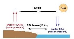
- Blows from sea to land
- Occurs especially during warm afternoonswith cloudless skies
- When insolation heats the land surface more rapidly than sea surface
- Layer of air in contact with land = warms up and expands
- This creates a Lower pressure areaat the Land surface and Higher Pressure area at surface of sea
- Surface wind starts to BLOW from SEA( Higher pressure ) to LAND ( Lower pressure)
- Typical windspeed : 10kts( Tropis : 15-20kts)
- Vertical Extend of affected area: up to 3000ft ( 1000ft-3000ft)
LAND BREEZE
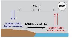
- Surface wind blowing from LAND TO SEA
- Occurs at NIGHT
- Land surface cools down more rapidly than the sea surface
- SEA ( Hotter ) = Lower Pressure
LAND ( Colder ) = Higher Pressure
- Pressure Gradient will cause the wind to blow from LAND TO SEA
- Typical Windspeed : 5kts
- Vertical extent of affected area : Up to 1000ft
ANABATIC WIND
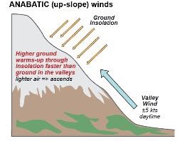
- UP-SLOPE wind from colder valley(lower areas) to Mountain top(warmer)
- K.A ‘ VALLEY WIND’
- Encountered in mountain areas ( Light= 5kts )
- Caused : Sun heats areas along sides of the mountain more than the lower areas in the valleys
- Increased temperature of the surface at the higher areas causes adjacent air to ‘ warm up ‘
- This air expands = lower density ( becomes lighter)
- This creates a flow of air : UP-SLOPE blowing wind
KATABATIC WIND
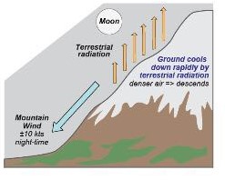
- Blows down from HIGHER ( Colder) areas along the mountain sides towards the LOWER(Warmer) areas.
- K.A ‘ MOUNTAIN WINDS’ ( light winds = 10kts)
- Blows Downslope
- Occurs at Night
- Caused : Rapid cooling of ground at HIGHER Levels( Terrestrial radiation)
- Adjacent air cools down as well = becomes Higher density (Heavier )
- Tends to DESCEND
- Most pronounced : When mountain sides are snow covered / skies are clear/ Greater radiation cooling
- Results in : COLD air DESCENDING into valley
GEOSTROPHIC WIND
- Wind that blows in a straight line Parallel to isobars
- Occurs only when there are straight(Parallel)and equidistant(constant Gradient) isobar, that are Not Changing with time.
- Geostrophic wind are affected by 2 forces only : Pressure gradient force and Coriolis Force
- For Geostrophic wind to exist , Following conditions must be met:
- Latitude is > 15 degrees North/South
- Straight and Parallel isobar pattern exists
- Pressure system is not changing rapidly
- No surface Friction ( Wind blowing above friction layer )
CORIOLIS FORCE
- Varies with latitude and windspeed
- Is zero at equator
- Increases with latitude
- Increases with an increase in windspeed
- Starts acting on airflow (90 degrees to the airflow direction) as soon as air starts moving and deflects it to the right( northern hemisphere) / Left in (southern hemisphere)
SUMMARY OF GEOSTROPHIC WIND
Geostrophic wind is :
- Directly proportional to Pressure Gradient Force ( P.G.F)
- Inversely proportional to Coriolis force
- Inversely proportional to Latitude
- Inversey Proportional to Density of air
GRADIENT WIND
- Non-Geostrophic wind
- Blows Parallel to Curved isobars
- More common than Geostrophic wind
- Affected by 3 forces : Pressure gradient force, Coriolis forceand Centrifugal Force.
Gradient wind circulation around a low:
- Gradient windspeed is LOWER than a Full geostrophic windspeed
- K.A ‘Subgeostrophic ‘
Gradient wind circulation around a high
- Gradient windspeed is HIGHER than full geostrophic wind
- K.A ‘ Supergeostrophic’
Highest windspeed
- Will be experienced as a result of a Large Horizontal PGF
- PGF is greatest when the Pressure gradient is ‘STEEPEST ‘
- g. : When pressure changes significantly over a relatively small horizontal distanceor Transition between two air masses
Surface winds
- Surface winds do not blow Parallel to the isobars as in case of the geostrophic and Gradient winds .
- Instead , they surface winds cross the isobars at an angle.
- It is because The Surface of Earth Exerts a FRICTIONAL DRAG on the air blowing closely above it.
- This friction is a resistive force and decreases the ‘wind speed’.
- Frictional Force is GREATEST at the SURFACE and gradually DECREASES with ALTITUDE until becoming zero at the top of the friction(Boundary ) layer.
- At this point the winds blow PARALLEL to isobars at normal geostrophic or gradient speeds.
- On average this Friction ( Boundary) layer is considered to extend up to about 2000ft.
- Over Land : Surface wind speed slows down 50% of the geostrophic winds and direction changes by about 30 degrees from the 2000ft winds
- Over Sea : Surface wind speed slows down to about 70% of the geostrophic winds and direction changes by about 10 degrees from the 2000ft winds.
- The surface winds are ‘ Backing ” in the northern hemisphere and ” Veering ‘ in the Southern hemisphere from the 2000ft wind directions.
- ‘Veering’ = a clockwise change in wind direction
- ‘Backing’ = a anti-clockwise change in wind direction
-When solving questions ,when you are given 2000ft winds( and above) ,use the ‘logic’ of verring/backing application.
- Given 2000ft winds and you’re asked to determine the Surface wind, the direction change to apply is ‘ backing ‘
- However, when given surface winds and you’re asked to determine the 2000ft winds , the wind direction change to apply is ‘ Veering ‘.
Summary
- Geostrophic wind( 2000ft wind) will not be geostrophic wind anymore below the frictional layer ,because it is affected by frictional drag . It changes to become SURFACE WIND
- How does it change ? : The wind direction ‘BACKS ‘ as it goes below the Frictional layer to become SURFACE WIND.
- How much does it Backs ? : It depends on the surface ( land/sea ) , wind direction backs 30 degrees and speed slows down to 50% of Geostrophic wind ( Land) and 10 degrees back and slows down to 70% geostrophic wind( Sea )
- On the other hand , Surface wind changes to become 2000ft winds with increase with altitude up to 2000ft .
- How? : The wind direction ‘VEERS’ with altitude up to 2000ft.
- How much does it back? : Same value as stated above .
- The above stated are for occurrence in the NORTHERN HEMISPHERE
- For occurrence in SOUTHERN HEMISPHERE,IT IS THE OPPOSITE .( e,g wind direction ‘VEERS’ going below the friction layer and ‘BACKS’ with increase in altitude up to the friction layer)
- Wind speed Changes in both hemispheres are the same. ( Decreases going below the friction layer and increases with increase with altitude up to the friction layer )
EXAMPLE QUESTIONS:
- If the wind at 2000ft is reported as 240/40kts , what is the most likely surface wind at an inland airport.(Northern hemispere)
Answer: 210 degrees/20kts
- Comparing the surface wind to the 3000ft wind .
Answer : Surface wind blows ACROSS the isobars and is Less than the 3000ft wind.
- What is the relationship between the 5000ft wind and the surface wind in the southern hemisphere?
Answer : Surface winds are veered from the 5000ft and have a slower speed.

You must be logged in to post a comment.